Weather Charts
Forecast Charts
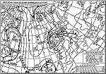
 Surface forecast
chart - ECMWF Reading
Surface forecast
chart - ECMWF Reading
Real-time observations can be used to generate a range of weather chart displays - showing current and immediate recent weather conditions and patterns. Forecast charts attempt to predict the future weather patterns and conditions - for the short (2 day) and medium term (3 to 7 day) future period.
Sophisticated computer analysis of the huge quantity of real-time data is used to create forecast charts. These show the predicted position of weather systems, from which deductions can be made about wind directions, wind strength, temperature changes etc. Forecast charts only show conditons for the short and medium term - long range forecasting is extremely difficult due to the large number of variable factors that affect our weather.
The European Centre for Medium Range Forecasting (ECMWF), based at Reading, UK, is a European Community weather analysis bureau, analysing data and providing regular forecast information for up to a week ahead.

ECMWF forecast charts - Surface pressure charts for North Atlantic region
Charts may be selected to show varying base forecast points and forecast states
UK Meteorological Office forecast charts - Surface pressure charts for North Atlantic and Europe
- Forecast pressure chart for tomorrow: T + 24 hours
- Forecast pressure chart for tomorrow: T + 36 hours
- Forecast pressure chart for 2 days ahead: T + 48 hours
- Forecast pressure chart for 2 days ahead: T + 60 hours
- Forecast pressure chart for 3 days ahead: T + 72 hours
- Forecast pressure chart for 4 days ahead: T + 96 hours
- Forecast pressure chart for 5 days ahead: T + 120 hours
Check the forecast charts!
How good was the forecast? Download and save (or print) a copy of a forecast chart. Wait until the day the forecast applies and check the actual weather. Compare the previous forecast with the real thing. Do they match?
Weather Forecast information

| Weather Forecasts for the UK
national, marine, regional and local forecasts in text summary formats. | |||||||
Weather Charts
Other weather chart information:

![]() Weather charts index and links page
Weather charts index and links page
Page creation: February 2009
This version: © Peter Milford